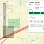
RICHMOND, Va.–(BUSINESS WIRE)–VertiGIS, a worldwide leader in spatial asset management solutions and geographic information system (GIS) software is proud to announce the latest addition to the new VertiGIS Networks product line: VertiGIS Network Locator. This innovative locates solution for underground utilities revolutionizes the way companies handle the demand of 811, Call-Before-You-Dig and One-Call responses with […]
New Edition of Esri’s ArcGIS Pro Guide Is Revised and Streamlined for Learning Latest Workflows
The Best-Selling Book Is Updated for ArcGIS Pro Version 3.1 Tools
Virtual Surveyor Unveils Photogrammetry App in Major New Release of Smart Drone Survey Software

Seamless Drone Surveying Workflow
Space Flight Laboratory (SFL) Announces Performance Milestone for GHGSat Greenhouse Gas Monitoring Microsatellites

TORONTO, Ontario, Canada, 6 September 2023 – Space Flight Laboratory (SFL) is pleased to announce the SFL-built GHGSat greenhouse gas monitoring microsatellites have achieved sustained detection and measurement of methane emissions at double the design capacity of the satellites. Under contract to GHGSat, SFL developed all nine operational 15-kilogram GHGSat spacecraft on its low-cost, high-performance NEMO microsatellite […]
Webinar Topic: Cameras on Drones and Aircraft: Is Bigger Always Better?

Webinar Announcement Hosted by Eric Andelin CP, Senior Workflow Specialist at SimActive and guest speaker, Kevin Graville, System Sales Manager at Phase One. Date: Thursday, August 17th 2023 Register here: https://hubs.ly/Q01ZS6Wz0 Aerial photography continues to thrive as a tool for mapping in spite of alternatives such as Lidar. Pictures can be collected using relatively low-cost cameras and converted to […]
SimActive Announces New Pricing for Larger Drone Cameras

Montreal, Canada, July 18th., 2023 – SimActive Inc., a world-leading developer of photogrammetry software, announces new pricing for its Correlator3D software. Larger drone cameras of up to 61 megapixels are now covered under the low-priced UAV license option, which was previously capped at 50MP.
Ecobot Launches StoryMap Demonstrating Regional Effects of SCOTUS Ruling

ASHEVILLE, NC / ACCESSWIRE / June 15, 2023 / Ecobot, the platform driving the digitization of mandatory pre-construction environmental assessments, today launched an interactive ArcGIS StoryMap to help environmental consultants and citizens understand how the recent Sackett v. EPA ruling by the Supreme Court of the United States (SCOTUS) will play out across the country based on existing local, state, […]
TCarta to Deliver Satellite Derived Bathymetry for 13 Regions to National Geospatial-Intelligence Agency
Work will be completed under contract to Maxar
Esri Releases New Desktop Software to Easily Synthesize All Sources of Information
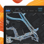
ArcGIS AllSource Connects Disparate Data, Enabling Actionable, Holistic Intelligence for Decision-Makers
The Essentials of Cloud – 2023 Kit

The Essentials of Cloud – 2023 Kit includes the latest in information, coverage of important developments, and expert commentary to help with your Cloud related decisions.